
I want to tell you about the moment I realised most Atlas Bergen content is completely useless.
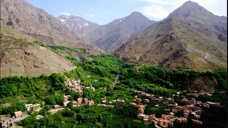
It was late afternoon on the Tizi ‘n Tacht Pass, somewhere around 2,700 metres. My legs burned. The salt-crusted guide in front of me had not spoken in forty minutes. Below us, the Azzaden Valley opened up, mud-brick terraces, walnut groves, a ribbon of river that caught the low sun like hammered copper. I pulled out my phone to check the “comprehensive guide” I had screenshot before losing signal. It told me the mountains offered “breathtaking views.” Thanks. Very useful.
Here’s what nobody told me: several of those terraced villages I was photographing were still partially rubble from the September 2023 earthquake that killed nearly 3,000 people. The gîte where I was meant to sleep that night had lost part of its roof. My guide’s cousin had lost his home entirely. The mountains I was romanticising were also places of grief, resilience, and a rebuilding effort that was still very much in progress.
That tension, the staggering beauty alongside recent devastation, is the honest context for visiting the Atlas Marrocos today. And it matters more than any list of “top trails” could tell you.
We can help you design a route that supports local communities and avoids common mistakes.
In this guide, I cover the practical facts every traveller needs: the three ranges and what makes each different, the best routes by fitness level, real accommodation costs, the earthquake’s lasting impact on trails and communities, when to go, how to hire a guide without getting ripped off, and the Berber culture encounters that will genuinely change how you see the world. I also tell you what I got wrong on my first trip, so you can skip those mistakes entirely.
The mountains in northwestern Africa are not a backdrop for your adventure. They are the home of the Amazigh people, a living landscape with a history stretching back thousands of years. Visit them with that understanding, and everything improves: the food, the conversations, the hospitality, and your own experience.
Table of Contents
What Exactly Are the Moroccan Atlas Mountains? (More Than One Range)

Most travel writing treats “the Atlas” as a single entity. That is misleading. The Morocco Atlas range system is actually three distinct ranges stacked across the country, each with its own character, altitude, and tourism infrastructure.
The High Atlas (Grand Atlas) cuts through central Morocco in an east-west sweep. This is where Mount Toubkal sits at 4,167 metres, making it the highest peak in North Africa. This range is also the primary trekking destination and the area most affected by the 2023 earthquake. If you are planning multi-day hikes, routes through Toubkal National Park, or a summit attempt, this is your range.
The Middle Atlas lies north of the High Atlas and offers a completely different landscape. Cedar forests dominate here. You will find Barbary macaques, natural springs, and the ski resort town of Ifrane, which Moroccans occasionally call “Little Switzerland” with only mild irony. This range suits travellers who want mountain scenery with less physical commitment and more accessible roads from Fes or Meknes.
The Anti-Atlas extends toward the south, where the mountains shade gradually into a pre-Saharan landscape. The Jebel Sirwa trek at 3,305 metres runs through this region. You will encounter fewer tourists here than almost anywhere else in Morocco, along with some of the most spectacular desert-mountain transitions on the planet.
Knowing which range fits your plan saves days of confusion. I have watched travellers book accommodation in Imlil, thinking they were near the Middle Atlas cedar forests. They were not. The ranges are hundreds of kilometres apart.
The September 2023 Earthquake: What Trekkers Need to Know in 2026

Let me be direct about this because most guides either ignore it or bury it in a footnote.
On September 8, 2023, a magnitude 6.8 earthquake struck the High Mountains of North Africa, approximately 72 kilometres southwest of Marrakech. It killed nearly 2,960 people, injured more than 5,600, and damaged or destroyed roughly 59,000 homes. For context, this was the deadliest earthquake in Morocco since 1960 and the strongest ever instrumentally recorded in the country.
Many villages along popular trekking routes, including some in the Imlil and Azzaden valleys, sustained significant structural damage. Roads were blocked by landslides. Several mountain gîtes that hosted hikers were damaged or destroyed entirely. When I hiked the region in early 2024, I passed through villages that were visibly mid-rebuild, with stacked timber and poured concrete sitting alongside crumbled pisé walls.
By early 2026, the majority of the main trekking routes will be operational again. The Toubkal summit route via Imlil functions normally. Most Imlil guesthouses have either been repaired or rebuilt. The Moroccan government launched a five-year, 120-billion-dirham (approximately $11.7 billion) reconstruction programme, and international organisations, including the EBRD, committed up to €250 million for recovery through 2025.
However, certain remote trails in Al Haouz province still pass through villages mid-construction. Some gîtes that existed before 2023 have not reopened. Always verify with your guide company before committing to a specific route. And when you do visit and stay in local guesthouses, know that your tourist dirhams are genuinely helping families rebuild.
Important: Before You Book
Always confirm with your guide or gîte that the specific route you plan to take is fully accessible. WhatsApp is widely used by local guides to send a message to confirm trail conditions. Do not rely solely on travel blogs written before September 2023.
Where do the Atlas Mountains start and end in Morocco?
In Morocco, these Mountains begin near Agadir on the Atlantic coast in the southwest and extend northeast to the Algerian border. The range spans roughly 1,200 kilometres within Morocco alone, passing through three distinct sections: the Anti-Atlas in the south, the High Atlas in the centre, and the Middle Atlas in the north. Most travelers combine this region with Morocco desert tours from Marrakech to experience both mountains and the Sahara in one trip.
What is special about the Atlas Mountains?

The Moroccan Mountains are home to Jebel Toubkal, North Africa’s highest peak at 4,167 metres. What truly sets them apart is the living Amazigh (Berber) culture in every valley: ancient mud-brick villages, saffron farms, and centuries-old hospitality. Nowhere else on earth combines this level of alpine drama with such a rich indigenous heritage.
The Best Trekking Routes by Fitness Level (Honest Assessments)
Here is where most guides get vague. Let me be specific.
If you want to experience the Atlas Mountains without trekking, a 4-day Marrakech to Merzouga tour offers the same landscapes with less effort.
Beginner: Imlil Valley Day Hike (4 to 6 hours)

Imlil village sits at roughly 1,740 metres and is about 90 minutes by road from Marrakech. From here, you can do a rewarding half-day walk through the Azzaden Valley to the village of Aroumd without any technical terrain. You gain about 400 metres of elevation across manageable rocky paths. This is suitable for anyone who walks regularly. The views from Aroumd across the High Atlas Bergen ridgeline are outstanding. Total cost with a local guide: approximately 300 to 500 MAD ($30 to $50). A shared grand taxi from Marrakech to Imlil costs around 150 to 200 MAD per person. If you prefer a guided experience, you can book an Atlas Mountains day trip from Marrakech instead of planning logistics yourself.
Intermediate: Toubkal Circuit (6 days)
This route loops through the Toubkal massif and saves the summit attempt for the final ascent, rather than rushing it in two days. You cover roughly 70 to 80 kilometres across varied terrain: walnut groves, high-altitude plateaus, isolated Berber villages, and rocky ridgelines.
Each day involves 5 to 7 hours of hiking with 800 to 1,000 metres of elevation gain or loss. I strongly recommend this version over the rushed two-day summit package that most operators sell. The circuit version is more expensive (typically $400 to $700 all-in with a licensed guide, mule, and gîte accommodation) but infinitely more rewarding. You actually meet people. You eat proper food. You stop to photograph a shepherd for reasons other than making your Instagram grid look adventurous.
Advanced: M’Goun Circuit (8 to 10 days)

The M’Goun Massif in the Central High Atlas is the Atlas Mountains‘ best-kept secret. Fewer tourists here means more authentic encounters with the Ait Atta and Ait Bougmez tribes, who still practice seasonal transhumance, moving their herds between mountain summer pastures and warmer winter grazing areas near the Sahara fringe.
The circuit passes through the spectacular M’Goun Gorge, where you walk in the river itself for stretches, wading through knee-deep water between 4,000-foot canyon walls that narrow to barely 10 feet apart. Mount M’Goun summit at 4,071 metres is an optional but spectacular add-on. Total cost ranges from $700 to $1,200, depending on group size and operator. MT Sobek and Wilderness Travel both run high-quality versions of this route. I rate both operators highly based on their local guide relationships and sustainable tourism commitments.
Accommodation in the Atlas Bergen: From $15 Gîtes to Sir Richard Branson’s Kasbah
The range is genuinely extraordinary.
| Type | Example | Cost Per Night | Best For |
| Mountain Gîte | Family guesthouse, Tizi Oussem | $15–$30 (incl. dinner + breakfast) | Trekkers, cultural immersion |
| Imlil Riad | Dar Adrar, Imlil | $25–$55 | Base camp comfort, valley views |
| Mountain Refuge | Refuge du Toubkal (CAF) | $20–$35 (dormitory) | Summit night stopovers |
| Kasbah Lodge | Kasbah Toubkal, Imlil | $90–$180 | Comfort trekkers, couples |
| Luxury Kasbah | Kasbah Tamadot, Asni (Richard Branson) | $400–$800+ | Honeymoons, luxury travellers |
My honest recommendation: stay in family-run gîtes wherever possible. The food alone, fresh tagines, enormous Moroccan salads, bread from a clay oven, proper mint tea poured from a height, is worth the entire trip. Gîte owners typically source ingredients from their own gardens or neighbouring farms. You are eating hyperlocal before hyperlocal was a marketing term.
Kasbah Toubkal, operated in partnership with the local Imlil village association (which receives a percentage of profits), hits the sweet spot between comfort and authenticity. It was partly used as a filming location for Martin Scorsese’s Kundun. It also runs the Imlil Hamam, which is open to trekkers for around $10 per person, highly recommended after day two.
Berber Culture: What Nobody Tells You Before You Arrive

Between 35% and 40% of Moroccans identify as Amazigh (the term most community members prefer over “Berber,” which historically derived from the Greek word for “barbarian”). In the Atlas Mountains specifically, the percentage is considerably higher. You are not visiting a place that happens to have some cultural heritage. You are visiting the homeland of a people who have lived in these mountains since well before recorded history.
Three things I wish someone had told me before my first trip.
First: the oral culture is everything. The Tamazight language passed down through generations entirely orally, only gaining an official status in Morocco’s 2011 constitution. When an elder tells you a story about a valley or a trail, you are hearing an unbroken chain of knowledge. Listen. Take nothing from it except memory.
Second: accepting mint tea is not optional. It is how trust begins. Every genuine interaction I had in the Atlas Bergen, negotiations with guides, evenings in gîtes, unplanned conversations in villages, started with tea. The three cups ritual (sweet, sweeter, sweetest) is real. If you decline, you create distance that is genuinely hard to close. Accept the tea. Put your phone down. Be present.
Third: women’s work is visible and central. Berber women weave rugs using patterns that encode family history, tribal affiliation, and personal memory. The craft is not a tourist performance. If you are invited to watch, you are seeing a working woman doing her actual job. Buying directly from a weaver in her home supports the community far more than purchasing from a souvenir shop in Marrakech’s medina. The difference in quality is also incomparable.
Cultural Tip
Learn five words of Tamazight before you arrive: “azul” (hello), “tanemmirt” (thank you), “wakha” (okay/alright), “ay akham” (my home, used when someone invites you in), and “ameslay” (great, excellent). Using even one of these words in the right moment generates more warmth than any amount of French or Arabic.
When to Go: Honest Season-by-Season Assessment
Most guides tell you spring and autumn are best. That is true but incomplete. Here is the real picture.
April through June is my preferred window. Wildflowers cover the lower valley floors. Temperatures at altitude sit between 10°C and 18°C during the day. The trails are snow-free above 3,000 metres from late April. This is peak season for the Toubkal summit, and for good reason. Expect more hikers on the main routes from mid-May onward.
September through November is excellent and often a better value. Golden light on the valley terraces, reduced tourist numbers, and cooler temperatures at altitude. November can be stunning, crisp and clear with occasional frost at night. I hiked a section in November and loved the quiet. You essentially have the valleys to yourself.
Winter (December through February) is for experienced mountain walkers only on anything above 2,500 metres. Toubkal in winter requires crampons, ice axes, and genuine alpine experience. The lower valleys are accessible and often strikingly beautiful with snow-capped peaks as a backdrop, but plan accordingly. A January 2024 hiker I spoke to reported 24°C at the trail start and ice-covered rock above 2,400 metres on the same day.
July and August are when I would advise most people to avoid the High Atlas. Heat in the lower valleys is brutal; temperatures above 35°C are common. The summit ridgelines can be manageable, but the approach routes are punishing. Save the Sahara extension for autumn instead.
How to Hire a Guide: The System, the Scams, and the Real Deal
Since 2010, hiring a licensed guide for trekking in the High Atlas has been mandatory. There are checkpoints on popular routes. This is not a suggestion.
Licensed guides charge between 400 and 700 MAD per day ($40 to $70) depending on route complexity and group size. Mule hire for carrying gear costs an additional 100 to 150 MAD per day. These rates are set by the Fédération Royale Marocaine de Ski et Montagne (FRMSA). Any guide quoting significantly below these rates is likely unlicensed.
The most reliable way to find a qualified guide is through Trek Atlas (based in Imlil, with strong online reviews as of 2025), Toubkal Guide, or by contacting Kasbah Toubkal directly, which maintains a network of vetted local guides. For the M’Goun circuit, operators like MT Sobek and Wilderness Travel handle logistics comprehensively at a higher cost but with strong safety records.
Here is the honest mistake I made on my first Atlas trip: I found a very enthusiastic man at a café in Marrakech’s Jemaa el-Fna square who offered to arrange everything, including a “certified local guide.” He was friendly. He spoke excellent English. He was not a guide. He was a fixer who subcontracted to an unlicensed village man who spoke no French or English and had no emergency training. We did not end up in danger, but we nearly did when I slipped on wet rock at 2,900 metres. Always verify the guide’s licence number. Licensed guides carry a card issued by the FRMSA.
What to Pack: The Non-Obvious List
The standard pack list is everywhere. This is what most guides leave out.
Trekking poles are worth their weight in gold on the descent from Toubkal. The loose scree from the CAF refuge down to Imlil destroys knees without them. Bring your own. Rental poles in Imlil are available but unreliable.
A Buff or lightweight balaclava matters more than a heavy hat at altitude. Temperature swings of 20°C between midday and sunset are normal above 3,000 metres in spring and autumn.
Small gifts for village children are a complex topic. Most experienced guides now advise against giving sweets or pens directly to children, as it creates the kind of begging culture that makes villages uncomfortable for everyone, including the children. Instead, bring a small donation to give to the gîte owner specifically for the village school, if one exists. Ask your guide how best to contribute.
Bring cash. ATMs do not exist in mountain villages. Imlil has one ATM that is sometimes operational. Marrakech cash is your insurance policy.
Food in the Atlas: Better Than You Expect

The stereotype is that Moroccan mountain food means basic tagines and plain couscous. The reality, in a good gîte, is considerably more impressive.
A typical trekking day’s food includes: breakfast of Moroccan flatbread with argan oil, amlou (almond-argan butter paste that I now genuinely miss), fresh fruit, and coffee or mint tea. Lunch on the trail means a packed spread of tomato-cucumber salad, harira soup in a flask, sardines or tuna, olives, and fruit. Dinner is usually the centrepiece, a slow-cooked tagine of lamb with prunes and almonds, or chicken with preserved lemon and olives, followed by sweet mint tea and fresh fruit. Vegetarians can be accommodated with advance notice. Vegans have a harder time but can survive well on salads, bread, and olive oil.
One memorable meal: sitting on the roof terrace of a gîte in Aroumd at sunset, eating a lamb tagine that had been cooking since morning, while the guide told me about his grandfather building the house by hand. The food was excellent. The context made it unforgettable.
Frequently Asked Questions
Where are the Atlas Mountains located on the map?
The Moroccan Atlas Mountains run diagonally across central and southern Morocco, from the Atlantic coast near Agadir in the southwest to the Algerian border in the northeast. They sit directly south of Marrakech and effectively divide Morocco’s fertile coastal plains from the Sahara Desert. On a map, they appear as a bold mountain spine cutting the country in half.
Do I need a guide to hike the Atlas Mountains?
Yes, it is legally required since 2010 for trekking routes above Imlil, and checkpoints enforce this. Beyond the law, a local licensed guide provides genuine safety value at altitude, navigates the complex trail network, facilitates cultural exchanges you would otherwise miss entirely, and contributes income directly to the mountain communities. Budget 400 to 700 MAD per day ($40 to $70) for a licensed guide from the FRMSA.
How difficult is the Mount Toubkal summit?
Harder than it looks on paper. The standard two-day route from Imlil involves a total elevation gain of about 2,500 metres. The final summit push from the CAF refuge involves loose scree at angles that make many people turn back. You do not need technical climbing skills in spring or summer, but you need solid cardiovascular fitness and experience with sustained steep ascents. In winter, crampons and ice axe experience are essential. Allow a six-day circuit itinerary rather than two days if time permits.
Are the Atlas Bergen safe to visit after the 2023 earthquake?
For the majority of established routes, yes. Main trekking routes, including the Toubkal circuit, are operational as of early 2026. Some remote trails in Al Haouz province still pass through villages mid-reconstruction. Always verify specific route conditions with your guide company before travel. Visiting also directly supports economic recovery in affected communities.
Can children hike in the Atlas Mountains?
Yes, with the right planning. The Imlil Valley day hike and lower Azzaden Valley routes are suitable for fit children aged 8 and above. Many guide companies, including Trek Atlas, offer tailored family itineraries with mule support for younger children who tire on longer sections. Avoid high-altitude routes above 3,500 metres with children under 12. Discuss your children’s ages and fitness levels honestly with the guide company before booking.
What is the best time to summit Toubkal?
Late April through June and September through early October offer the best conditions: snow-free routes from late April, stable weather windows, and manageable temperatures. July and August work but require very early starts (3 a.m. from the refuge) to beat the afternoon heat. Winter summit attempts (December through March) require full alpine equipment and experience, crampons, ice axes, and a guide with winter mountaineering certification, which are non-negotiable.
How do I get from Marrakech to Imlil?
A grand taxi (shared long-distance taxi) from Bab Rob square in Marrakech runs to Asni for about 30 MAD per person, then you change to another grand taxi to Imlil for 15 to 20 MAD. The full journey takes about 90 minutes. Private transfers cost 200 to 350 MAD and take the same time without the wait. Your gîte or guide company can usually arrange this in advance for a small surcharge, which is worth it for the first trip when you do not yet know the city.
Final Thoughts: Go. But Go Honestly.
The Atlas Marrocos will give you exactly what you bring to them. If you arrive looking for dramatic views and Instagram coordinates, you will find those. The views are genuinely extraordinary. But you will miss the point by a significant margin.
Bring curiosity about the Amazigh people who have called these mountains home for millennia. Bring patience for the pace of mountain life, where no one measures distance in kilometres. Bring a willingness to sit with a cup of mint tea and let a conversation go where it goes. And bring an awareness of the grief and rebuilding that is still present in these valleys, nearly three years after the earthquake that shook the entire range.
The Mountains of Morocco are not a backdrop. They are a living place. Visit them on those terms, and you will carry something from this trip that no photograph can hold.
What is drawing you to the Atlas Bergen? A summit attempt, the culture, the desert extension, or something you cannot quite name yet? I would genuinely like to know. Drop your question or your plan in the comments below, and let’s figure it out together.
Leave a Reply